Navigation
Safe Boat Driving – Lake Norman Boating Navigational Aids
Aids to Navigation (ATON) – ATONs are the channel markers, shoal markers, no wake buoys, and informational buoys throughout the lake. Numbered and lighted Channel Markers for both the main lake and major creeks begin at Cowans Ford Dam on Highway 73 and continue northward to Buffalo Shoals Bridge. Keep the RED triangular buoy on the boat’s starboard (right) side when proceeding up the lake or when entering a channel from the main body of water. Creek channel marker numbers will get higher as your travel away from the main channel. DO NOT pass between the marker and the shore. There are also lighted and unlighted danger markers indicating a shoal or rocks. DO NOT go near these markers.
Please report any problems with Aids to Navigation (ATON) to the Lake Norman Marine Commission. Problems with ATONs include: marker is missing, lights not working, signs missing or faded, poles leaning, buoys out of position, buoy damaged and/or not floating properly. When reporting a problem, please provide as much information as possible, i.e. sign number/letter(s), location with GPS coordinates (if possible). Also, please include contact information (name, email address, telephone number) in case the Lake Norman Marine Commission needs additional information.
Water Depths
Lake levels can vary as much as 8 feet in normal operation. They are generally drawn down during the fall and winter months. Call Duke Energy’s toll free number at 1-800-829-5253 for hourly updates or go online at https://lakes.duke-energy.com or Duke’s Lake View app
Bridge Clearances
The Catawba River Channel that winds through Lake Norman is spanned by five major bridges & sixteen additional bridges cross creeks or connect exclusive island properties to the mainland. Listed below are the approximate vertical bridge clearances when the lake is at full pond (760 feet above sea level). Wave height must be factored in when boat clearances are tight.
- I-40 Bridge – Catawba River – over 10′ 0″
- Highway 70 Bridge – Catawba River – over 10′ 0″
- Railroad Bridge – Catawba River – over 10′ 0″
- Railroad Bridge – Buffalo Creek – 3′ 0″
- Buffalo Shoals Rd. Bridge – Catawba River – over 10′ 0″
- State Rd. 1832 – Balls Creek – 5′ 6″
- Windermere Island Bridge – Catawba River – over 10′ 0″
- Mollys Backbone Rd. Bridge – Terrapin Creek – 2′ 0″
- State Park Rd. Bridge – Hicks Creek – 3′ 0″
- Perth Rd. Bridge – Rocky Creek – 3′ 0″
- Perth Rd. Bridge – Cornelius Creek – 5 ‘3″
- Cornelius Rd. Bridge -Cornelius Creek – 4 ‘0″
- Highway 150 Bridge – Catawba River – 8′ 5″ & 11′ 1″
- Highway 150 Bridge – Mountain Creek – 5′ 9″
- Highway 150 Bridge – Reed Creek (LKN Marina) – 5′ 9″
- Mount Pleasant Rd. Bridge – Mountain Creek – 5′ 5″
- Railroad Bridge – Mountain Creek – 6′ 3″
- Slanting Bridge Rd. – Mountain Creek – over 10′ 0″
- Governors Island Rd. Bridge – East of Burton Creek – 7′ 10″
- Williamson Rd. Bridge – Reeds Creek – 6′ 0″
- I – 77 Bridge – Reeds Creek – 10′ 3″
Hazards to Navigation
Each year the winter draw down of Lake Norman’s water level exposes serious hazards to navigation, including rocks, stumps, humps, sandbars, etc. As the lake fills, shallow water covers many of these perilous areas during the summer. Danger spots are everywhere. Some are identified by channel/shoal markers and buoys, but many are not. “Boater beware” should always be on your mind when navigating in unfamiliar waters. A quality lake map, GPS, and a good depth finder are necessary for safe boating experiences. The following are specific locations and types of conditions that pose hazardous situations on Lake Norman.
Channel Marker adjacent to Shoal Marker(s): Do NOT pass between the two markers. This is NOT the channel. The markers are identifying the area between as a hazard. On the main river channel there are several such areas. Shoals are located at markers 1A, 2A, 6, 10, and 15A. Shoals also are in proximity to creek channel markers R4, R5, D3, D4, D8, T1, T2, T4 and M1. These areas should be identified as danger zones on your area lake map.
Islands: Most of Lake Norman’s beautiful islands are continuations of adjacent points of land. The water between the point and the island is often very shallow. Therefore, to avoid stumps, rocks and gravel just under the water, it is prudent to maneuver around the outside of the island. Few island passes afford adequate warning information. A good example is the chain of islands on the Denver side of the lake, beginning with Governor’s Island and continuing south toward the point of land near the end of Unity Church Rd. These islands are surrounded by shallow water and numerous hazards.
Shoals: The dictionary defines a shoal as “a shallow place in a body of water”. Lake Norman has too many of them to identify with markers and buoys. One of the lake’s most dangerous shoal areas is south of marker R1. It is dotted with a line of shoal markers, indicating a flooded road bed that was once the northern portion of Beatties Ford Rd. Upriver, multiple shoal markers identify the low water adjacent to marker 15A. This area is particularly dangerous since the shoals are in a high traffic area in a turn on the river channel.
Rocks: Rocks are a boater’s worst underwater enemy. They damage or destroy hundreds of boat propellers annually. Rocks and rock piles are scattered throughout Lake Norman. Most are not identified by signs or markers.
Congested Areas: No-wake areas near marinas, gas docks, yacht clubs and lakeside restaurants are particularly dangerous due to heavy boat traffic. When approaching such areas, all passengers should watch for dangerous passing situations.
Bridges: Pilings obstruct the view of oncoming boat traffic. For this reason, area bridges are considered to be no-wake zones. No wake means NO WAKE. If you can see a wake behind your boat, you are going too fast. Also consider a boat’s vertical clearance when passing beneath a bridge. Bridge clearances change with the water level and with wave and boat wake disturbances.
Catawba River: The river section of Lake Norman from Buffalo Shoals, north to Lookout Shoals Dam, is not marked. During periods of low water levels, portions of the river channel are un-navigable. It is unwise to venture north of Bill’s Marina unless you are in a shallow draft boat and are with someone who is familiar with the channel.
Moving water: Water current poses another set of challenges for an unfamiliar boater. Boaters need to know that water runs almost continuously in the discharge canals at the Marshall and McGuire Power Stations. Strong currents also occur upriver during flood conditions and when water is being discharged from Lookout Shoals Dam.
Protruding Structures: Water intakes and long boat docks are particularly dangerous when navigating at night. These structures are not always lit and might lack reflective devices that make them visible. To avoid a hazardous collision, run at a considerable distance from shore.
Unlit Aids to Navigation and Boats: Not all markers, buoys and boats are properly lit during low light conditions. Navigating at night should be at reduced speeds and with additional people to watch.
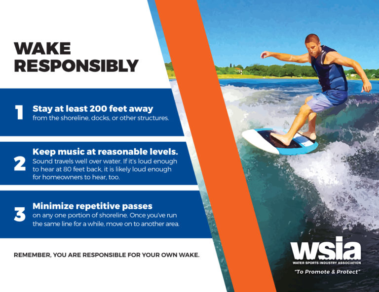
Wake Boat Responsibly